
![]()
![]()
![]()
What is Les Transformation de Southport?
While Prince Lous Napoleon, later Emperor Napoleon III was living in exile in Southport in 1838, he was so inspired by the town’s architecture that he subsequently ordered the reconstruction of Paris based on the town’s grandeur.
“Les Transformations de Southport”, aims to improve connectivity across the town centre, including improved pedestrian and cycling routes with the waterfront, and the creation of new public spaces for hosting events.
The first phase of the project is improving the roads and pedestrian spaces near Southport Market. Phase Two, this phase, will improve Southport Promenade.

| The new Marine Lake Events Centre building on the seafront |
The new Marine Lake Events Centre building on the seafront. It shows there will be plants and paths for people to walk to the centre. The picture is made by AFL Architects.
Why now and why the Promenade?
The Promenade proposal will make it easier to walk, cycle, or take the train when making a journey to the MLEC.
- We want to make it easy to get to the MLEC with safer routes and public space.
- We want better ways to travel between the town centre and the seafront.
- The plans will connect with local cycling and walking routes.
Why are public realm, walking and cycling improvements good?
Making it easy for people to walk and cycle is important for the success of the MLEC and our seafront. It helps people to stay healthy and reduces traffic and pollution for the benefit of pedestrians.
Improving public spaces supports people wanting to visit the town centre. This can lead to more shopping and spending. Better design using greenery can also help with capturing rainwater and make the area more pleasant for everyone.
Where are the projects located?
Below is a map showing where three related projects are in Southport town centre. This shows:
- Phase 1 of LTDS on Market Street, King Street, and Eastbank Street.
- Phase 2 of LTDS is on Nevill Street, Marine Parade, Bold Street, and The Promenade.
- The Marine Lake Events Centre is on The Promenade in the location where the Southport Theatre used to be.

| Map showing the phasing of Les Transformation de Southport |
This is a map showing the location of the proposed changes to the highways in Southport to support the MLEC.
What will happen to traffic movements?
This project has been carefully designed to generate less through traffic, creating space for much-needed improvements to public areas and pedestrian facilities.
A key element of the plan is to formalise the central reservation on The Promenade, transforming it into a green spine. This new feature will enhance the environment, create a dedicated cycling route, and help prevent traffic from cutting through residential streets in the town centre. Additionally, limited junction movements at the Promenade/Marine Parade intersection will help reduce waiting times for both pedestrians and motorists.
The key changes are as follows:
- Nevill Street will only allow cars to go one way north, past West Street.
- The Promenade will change to have a middle section with a cycle path. This will stop cars from cutting through Bath Street and keep cyclists safe.
- Marine Parade will only let cars turn left onto the Promenade and left into Marine Parade from the Promenade.
- The top part of Bold Street will change to only allow traffic to go southbound from the Promenade.
- Parking on the Promenade will be organised on the south side to provide sixteen parking spaces for cars.
- There will be new spaces for taxis, disabled parking, drop-off areas, and coach bays. This will help people get to the MLEC by these modes of travel.
- Eight new pedestrian crossings will be added for people walking. Some will have traffic lights, and some will not.
- The road will be narrower on the Promenade to give more space for pedestrians.
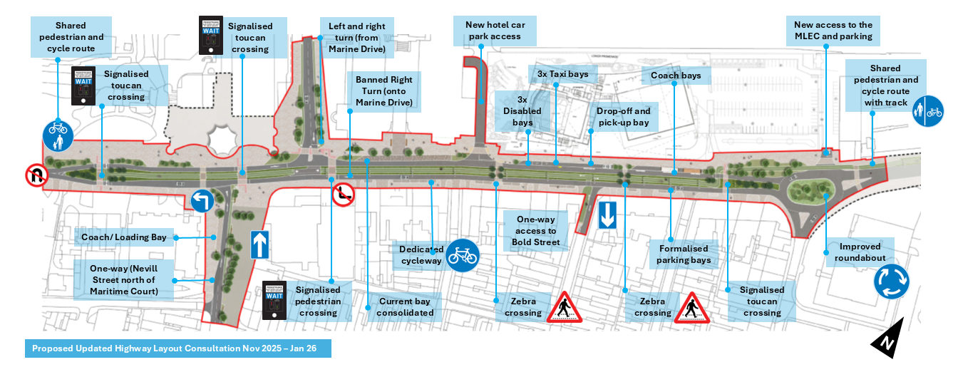
Click to enlarge. A map outlining the highway changes proposed for the area. (Alt: A map demonstrating the highways changes outlined in text above).
What is happening to the landscape design?
The landscape design of the project builds on the benefits brought by the highway changes, which will include wider footways due to narrower carriageways and additional crossing points. Sign posts, street lighting and parking facilities will be improved. Similar to Lord Street, greenery such as trees and grasses will be planted along the length of the Promenade to make the street. This will soften the appearance of the Promenade and add character. Key interventions include:
- New paving, signs and direction information will be provided. New trees and grasses will be planted. The new trees and grass will make the area greener and more pleasant.
- New tree and grass planting.
- Cycle lanes and bike parking will be provided. This is good for health and the environment.
- The traditional lighting columns will stay. They help keep the area's character. There will be new seating areas to sit and rest, such as benches.
- Tactile paving will be provided in some areas near the road crossings. This will help people who are blind or partially sighted.
Final Plan and Visuals
Proposed plan of the Promenade

| Visualisation for the Promenade |
This picture shows the new plan for the Promenade. It has a 3D image of the MLEC building, a new pedestrian crossing, better paving materials, and plants. The picture shows people crossing the street and walking to the MLEC building.

| Visualisation for the Promenade - Plants, trees and cycle lane |
This picture shows what the changes might look like when viewed along the Promenade. There are plants and trees, a path for bikes, and parking spaces.
FAQs
The new design will encourage drivers to route around the centre of the town rather than through it. Vehicles will be directed to use streets such as Seabank Street, Leicester Street, Park Street, and Marine Drive to access the seafront to the north. Similarly, routes like the Esplanade, Duke Street, and Kingsway will connect the two areas to the south. This design will discourage large numbers of traffic from interfering with the heart of the town centre, particularly outside London Square. This will achieved by changing Nevill Street from a car-dominated road to one that prioritises people.
The proposed changes have been evaluated using a traffic model, and it has been determined that there will be no significant impact on traffic flow or congestion in the area, even during peak summer traffic conditions.
The central reservation ensures several objectives are met. The central reservation creates the street's green corridor. The green planting will link and provide space for cyclists and improved pedestrian crossings. This feature will still make sure ensure kerb edges of the Promenade retain their functions with the addition of a cycle lane.
Accessing these streets from the northbound carriageway of the Promenade will no longer be possible via a right-hand turn because of the central reservation. Vehicles needing to reach Nevill Street, the Promenade, Seabank Road or Lord Street will need to use alternative routes, including the upgraded Seabank Road/Promenade roundabout. This will allow drivers to access the southbound carriageway of the Promenade and turn left into the Bath Street area. Those who need to access Nevill Street will have to do so from West Street, Bath Street and Lord Street.
Parking will remain available along the southbound edge of the Promenade’s carriageway. Spaces will be formalised to meet current highway standards and accommodate the complex access requirements along the southbound edge of the Promenade. A total of seventeen formal parking spaces will be available, with additional drop-off and pick-up spaces located outside MLEC. Long-term parking will also be available in nearby council car parks.
An informal crossing point includes dropped kerbs, tactile paving, and changes in surface appearance to provide a less formal but safer pedestrian crossing point. While it does not include signals, it relies on the judgment of pedestrians to assess when it is safe to cross. This design provides safer crossing points without frequently interrupting traffic flow with a more formal signalised crossing.
The proposed cycle lane is part of Sefton’s Local Cycling and Walking Infrastructure Plan, which identifies the Promenade as a key route for connecting residential areas, employment zones, and local amenities. The Promenade is wide enough to accommodate a cycle lane without compromising space for vehicles, pedestrians, and other modes of transport. The central location of the cycle lane ensures a direct and safe route that does not interfere with kerbside activities such as loading, parking and taxi bays.
Cycle parking will be integrated into the design as part of the overall scheme.
Funding is identified in the agreed transport capital programme for detailed scheme development. Discussions are ongoing with the Liverpool City-Region Combined Authority for the funding to deliver the scheme. It is aimed to have the whole scheme delivered for the opening of the MLEC.
Surfacing materials will be consistent with the "Les Transformation de Southport" Phase 1 scheme on Market Street, creating a cohesive and distinct Southport palette for use across all future projects. Planting will reflect the coastal nature of the area, using coastal grasses and other low-maintenance plant options.
The scheme will include frequent seating to ensure the space is accessible for everyone. These areas will allow people to enjoy the new public space and take breaks if needed during longer walks.
The design will include contrasting colours in the pavement to highlight crossings, servicing bays for delivery vehicles, and footways. Tap rails, tactile paving, and other measures will help people who are blind or partially sighted navigate the area. Tactile paving will also help distinguish formal and informal crossings. Benches and dropped kerbs will be provided to accommodate those with mobility impairments.
The existing historic lighting columns will be retained within the central reserve.