




We engaged with some local residents from 2nd March and 27th March 2026 to gain feedback around two proposed designs on the A59/Dodds Lane junction.
The engagement asked for feedback about proposed A59/Dodd’s Lane junction improvements. We focused on initial feedback from local residents regarding the change to the service roads and presented two initial options.
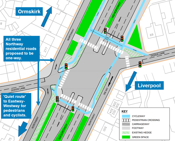
Concept A proposed making all service roads one way coming off the A59.
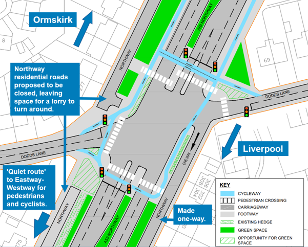
Concept B proposed the closure of the service roads on the northbound side of the A59, and putting in vehicle turning heads.
You said:
- 71% of individuals said they agree or strongly agree with the proposals to improve the A59/Dodd’s Lane junction. 7% were unsure.
- 26% of individuals who responded said they disagreed or strongly disagreed with the junction proposals to improve the A59/Dodd’s Lane junction.
- Among those that were supportive, 52% were not sure which of the two concepts to support. 23% supported the changes proposed in concept A and 26% supported the changes proposed in concept B.
We did
The feedback showed most people supported the idea of junction improvements but no particular concept option emerged strongly, other than the overall support.
Other suggestions such as a roundabout, underpass, bridge were suggested, and further traffic counts to review the wider impact of any change.
There were further comments related to road safety, vehicle speeds and large vehicles on residential routes. As a result, we have arranged traffic surveys. These were carried out in May. The data has been used to review options, including those suggested by the public.
This means there will be further evaluation. The alternative options provided by the public in March 2026 are being evaluated in the next design stage from August 2026 to November 2026. The council will be engaging on the proposals in November 2026.
Dodd’s Lane is located on either side of the Northway (A59) dual carriageway in Maghull, providing access to residences, local businesses and services.
Dodd’s Lane has been chosen for junction and active travel improvements due to its lack of crossing facilities. These improvements will allow for an extension of the Northway Cycleway southbound, with future junction upgrades planned for Eastway/Westway, approximately 350m to the south of the Dodd’s Lane junction.
Active travel means making everyday journeys as a pedestrian or without a vehicle, such as by walking, wheeling, or cycling. Trips to school, work, the shops or to visit friends and family might be by active travel. It can also form part of a longer journey, such as walking to the bus stop or cycling to the train station.
By encouraging more people to choose active travel and by making our highways safer, we can help improve health and wellbeing, and create more attractive streets for everyone.
We have been keen to engage early in the design process because a safety improvement at the A59 / Dodds Lane junction will require changes to the residential service roads. These minor roads that connect into Dodds Lane junction serve people’s homes for both personal vehicles and service vehicles.
Considerations are to close the service road connections into Dodds Lane junction whilst leaving space for bin lorries to turn-around, or to make them one-way from the junction. In both options, the junction will function better when pedestrian crossings are installed.
After engagement in March, the feedback from the public has been carefully considered and illustrated. We are now sharing the illustrate plans as well as preferred option to put traffic signals on the junction.
Installing traffic signals on the junction will provide both safety and traffic management benefits to the junction.
We could introduce clearly marked and dedicated right-turn lanes on both sides of the A59. Doing so will help drivers benefit from enhanced confidence and safety when turning right, reducing the risk of accidents. Furthermore, traffic modelling shows that reducing the A59 from three lanes to two lanes at the junction will not affect overall traffic flow. This change allows for wider footways, creating more space for pedestrians without compromising road efficiency.
Together, these improvements aim to ensure that traffic remains steady while reclaiming valuable space for those choosing to travel by foot or bike, supporting a safer and more inclusive environment for everyone.
Some at the March public engagement events suggested a footbridge. While constructing a pedestrian footbridge across the A59 was considered, this option would have required purchasing extra land to meet the latest design accessibility standards that require more gradual ramps, to ensure a bridge could be used comfortably by everyone. This would have significantly increased the cost and complexity of a bridge with no benefit to motorists at all.
There a many trees that line the A59, which are important for nature and the pleasant feel of the area, but also help suppress road noise. To build a bridge would require tree loss to accommodate it, and we do not want to lose tree cover in the area.
Instead, we have decided to enhance the existing signalised crossings at the junction. These improvements will provide safer and easier access for pedestrians, offering a quicker and more cost-effective solution without compromising on accessibility.
A roundabout has been carefully considered as an option, and some people suggested it in March.
We have considered this and identified it is not feasible within the space available unless difficult compromises were made. This is because a roundabout of a sufficient size to accommodate the traffic volumes would need to procure land on resident’s properties to get the width of roundabout required. This would be a challenge and very impactful.
As such, it is not a preferred option when using traffic signals is a much more deliverable approach to addressing the traffic and pedestrian safety problems at the junction.
The scheme is to be considered for delivery in 2028, as part of a funding programme called Transport for City Regions (TCR). You can find out more about the TCR programme on the government website.
There are three main ways to get involved:
Complete the engagement survey on Your Sefton Your Say
- Paper survey
Request a paper copy by visiting Maghull Library who will be able to provide a physical copy and return the survey to the same location, or by email or post to:
Sefton Council, Transport Planning, Bootle Town Hall, Oriel Road, Bootle, L20 7AE.
- Drop-in events
Meet the project team, view updated designs and ask questions at the next public engagement events:
| Event | Venue | Date | Time |
| Drop-in Session 1 | Maghull Parish Hall | Monday 16th November 2026 | 9:30am to 11:30am |
| Drop-in Session 2 | Maghull Cricket Club Clubhouse | Tuesday 17th November 2026 | 7pm to 9pm |
| Drop-in Session 3 | Northway Primary School | Thursday 26th November 2026 | 4:30pm to 6:30pm |
No booking is required. Please contact us in advance if you require information in another format (large print, translated documents).
After this engagement:
- We will review all feedback and update designs accordingly.
- All responses reviewed will be summarised in an engagement report which will be published on the Council’s website.
- Responses received will assist in informing the next stage of design
You can email the project team at transport.planning@sefton.gov.uk