




Phase 2 – Kew Roundabout/Foul Lane/Scarisbrick New Road
Southport Eastern Access Phase 2 aims to make it easier for vehicles, pedestrians and cyclists to move around and travel in and out of Southport and around the Norwood area.
Benefits of the scheme
The changes will see major changes around Kew Roundabout and the opening of Foul Lane to traffic. The introduction of signalised crossings at Kew Roundabout on every arm will make crossing by the roundabout by either walking, wheeling or cycling easier. This will also make it easier for motorists navigating the roundabout.
Additionally, works will improve access to the retail park and industrial units by opening Foul Lane to traffic, making it easier to access shopping and leisure, and improving access to businesses.
The scheme improves access and safety to the area, as well as improving the look and feel of a key public area. With are schools and colleges nearby, there will be younger people likely navigating the area without a car. Following improvements, this will be easier and safer.
The area is also a key route into Southport, and the improvement of the roundabout and opening of Foul Lane will make it easier for cars to navigate through to Southport, as well as improving the look and feel.
Changes
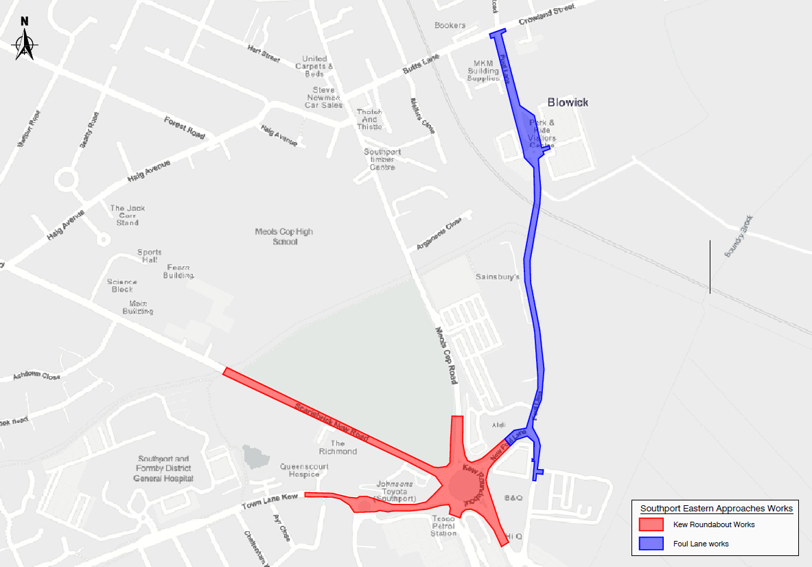
The map above shows the area the works will take place, including on Kew Roundabout, Scarisbrick New Road, and Foul Lane.
Kew Roundabout
Kew Roundabout will see significant changes, with the introduction of traffic lights and signalised crossings, and the introduction of segregated footpath and cycle path. This will make it significantly easier for pedestrians and cyclists to navigate the area.
Scarisbrick New Road
Scarisbrick New Road, alongside the park will see a widening of the footpath and introduction of a cycle path, this will be on the park side of the carriageway. This will connect to Kew Roundabout. The current crossings will be upgraded to a pelican crossing.
Foul Lane
Foul Lane will be opened up to traffic, so turning into Foul Lane from Crowland Street continues all the way through. There will be carriageway widening to accommodate this, and the footpath and cycle path will be improved through widening and improved segregation between the paths.
Where the road is currently blocked on Foul Lane will be removed, opening it up to through traffic, and the segregated footpath and cycle path will become a shared path continuing down Foul Lane.
Continuing down Foul Lane, past the mini roundabout towards B&Q, there will be an introduction of a segregated queuing lane from the mini roundabout to turn left into Southport Household Waste Recycling Centre.
Location and Phasing for Southport Eastern Access
The Southport Eastern Access improvement scheme is from Eastbank Street/Bridge Street to Kew Roundabout, and connects to Foul Lane and Meols Cop Station.
The scheme is focused on introducing new and upgraded junctions and active travel (walking, wheeling and cycling) routes along:
- Scarisbrick New Road
- Southport Road
- Kew Roundabout
- Foul Lane
- Meols Cop Road
- Norwood Road
- Haig Avenue.
The scheme aims to make it easier for vehicles, pedestrians and cyclists to move around the area. The scheme has been split into different phases.
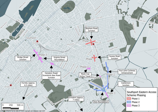
Phase 1 – Completed 2025
- Bispham Road Junction
- Sussex Road Junction
Phase 2 – To be delivered in 2026/2027
- Foul Lane Cycleway Enhancement (corridor improvement) - originally part of Phase 1
- Kew Roundabout
Phase 3 – To be delivered beyond 2027 (subject to funding)
- Castlemore Junction
- Meols Cop Active Travel
- Hampton Road Tiger Crossing
- Virginia Street Roundabout
- Bridge Street Junction
The Map below shows the walking and cycling improvements as well as the junctions which are going to be improved. For more detailed plans, check out the related links on this page.
| SEA Phasing Plan PDF (updated April2025) |  (pdf 741KB) (pdf 741KB) |
Aims of Southport Eastern Access
Southport is recognised as a key area in the borough. The scheme is part of plans to grow the economy and improve public spaces and transport networks.
The scheme will improve the road network, footways, and cycling routes between Southport town centre and the Southport Road border in Kew.
Plans will:
- Tackle congestion issues,
- Tackle “rat running” on key routes to and from Southport town centre, including Scarisbrick New Road and through the local area including Norwood road, Meols Cop Road, and Butts Lane,
- Improve access to Kew Retail park and the wider area
- Improve access to the industrial units on Crowland Street
- Update walking and cycling paths on the eastern side of Southport.
- Allow traffic calming and safety measures to be developed and implemented,
- Improve the look and feel of key public areas.